Research - (2021) Volume 0, Issue 0
Analysis of climate changes on the Ternopil plateau in 1961-1993 basing on the average annual data
N.B. Taranova*, T.B. Zastavetskyi, M.R. Pytuliak and M.V. PytuliakAbstract
The study aims to historically evaluate and analyze the climate changes of the Ternopil Plateau in 1961-1993 basing on average annual indicators. Nowadays, climate change is one of the most up-to-date problems for the world community. We analyzed the data of long-term observations of various climatic changes at the weather station in the late 20th-early 21st century. We highlighted specific conditions that significantly affect the thermal regime of soil and air, air humidity, and atmospheric pressure, determining weather conditions like wind, cloudiness, and precipitation on the Ternopil plateau. The research methodology is based on the principles of climate monitoring in Ternopil conducted for about 140 years. The first data on average annual temperatures were published in 1881, but the observations are incomplete since interrupted periods during World Wars I and II. The article analyzes the published data of the 1961-1993 period and material collections from the Ternopil weather station. This work has applied methods to analyze the primary meteorological data for 1991-1993 and search for evidence of their interconnection. The influence of landscape conditions on the indicators and meteorological data distribution has been analyzed. The scientific novelty lies in the fact that the historical analysis of climate changes of the Ternopil Plateau in 1961-1993 basing on average annual data has been done for the first time in 32 years and corresponds to the climatological norm. On this basis, we can conclude the statistical parameters and tendencies of climate changes of the Ternopil plateau landscape. The city of Ternopil has the status of a regional center and has a significant influence on the topoclimatic feature formation due to its size. The weather forecast measurement in Ternopil is 49° 32' N lat., 25° 40' E long., the altitude is 327 m above sea level. Based on climatic materials published in «Meteorological monthly journals» and material collections, the climatic specificity of the Ternopil weather station as a representative object for the Ternopil plateau landscape (the period of 1961-1993) has been analyzed. According to climatic indicators, we can conclude that the dynamics of the Ternopil plateau's climate changes during this period affect the changes of landscape components (soils, flora and fauna), people's economic activity, characteristics, and intensity of dangerous natural phenomena.
Keywords
Climate, Ternopil plateau, thermal regime of air and soil surface, air humidity, atmospheric pressure, wind regime, and precipitation indicators.
Introduction
A characteristic climate feature of the late 20th-early 21st century is an increase in air temperature near Earth. Current warming is revealed by the growth of several abnormal atmospheric phenomena. The global air temperature near the Earth's surface is observed to be increasing at an average speed of 0.15-0.20°C every ten years since the 1970s (IPCC, 2001; Climate Change, 2001). The critical increase in air temperature during the period of industrialization makes up 2.0 °C. If this indicator is exceeded, the risk of irreversible environmental disasters rises.
The increase in air temperature by 3.0-4.0°C is assumed to lead to precipitation, air temperature, and sea-level changes, resulting in severe consequences: 20-30% of terrestrial plant species will disappear, flood types and watersheds will disappearlevel changes which will result in serious consequences: 20-30% of terrestrial plant species will disappear, flood types and watersheds will change, the number of tropical typhoons will increase. All this will lead to significant socio-economic problems all over the world. The temperature regime characterized by some indicators is an essential characteristic of the climate. One of the main indicators of the temperature regime is the average month air temperature which reflects the total temperature background of the territory. The air and soil temperature, air humidity, atmospheric pressure forming the wind regime, cloudiness, and precipitation are determined by the geographical location of the territory, radiation regime, and circulation factors. We have carried out a historical analysis of the leading meteorological indicators in terms of global climate changes taking the Ternopil Plateau as an example.
Modern climatic changes in the territory of Ukraine are studied by many scientific schools, among which the works of the Ukrainian Scientific Research Hydrometeorological Institute take a special place. The temperature regime on the territory of Ukraine is well-analyzed in Babichenko V. M.'s works (2008, 2010).
The analysis of air temperature in comparison with the climatological standard rate in 1961-1990 period revealed the tendency to its growth, and there were also changes in the dates of steady transition of the average daily air temperature through 0, 5, 10, 15°C in spring and autumn in the current climate. Climatic characteristics of the maximum air temperature on the territory of Ukraine for the 45 years (1961-2005) are presented in the works by Osadcha V.I., Babichenko V.M. (2008, 2010), Osadchyi, V., Skrynyk O. A., Radchenko, R., Skrynyk, O. Y. (2018).
The purpose of the research is to analyze the climate changes of the Ternopil plateau in the 1961-1993 period basing on average annual data. We have defined average values of the main meteorological parameters and their standard deviations using physical and statistical analysis of meteorological data. The graphical method enabled us to detect space and time changes in the studied area.
Materials and Methods
Landscape climate research also requires special methods. The research methodology is based on the principles of climate monitoring in Ternopil conducted for about 140 years. The first data on average annual temperatures were published in 1881, but the set of observations is incomplete since there were interruption periods during the World Wars I and II. The article is based on the analysis of the published data of the 1961-1993 period (Meteorology monthly journal, 1961-1994) and material collections from Ternopil weather station. Since the data consist of indicators from meteorological stations or other similar sources, the research methods remain the same as in the microclimate study, though the application of these data is different.
To study the landscape climate, it is necessary to:
1. To analyze the data of long-term observations at meteorological stations, and the longer the observation is, the more valid results are. The data used for writing the article have been obtained from the Ternopil weather station and have been regularly published in monthly meteorological journals from 1961 to 1993. Also, material collections from the Ternopil weather station are considered;
2. To build a network of several permanent observation points in typomorphic natural complexes of the landscape;
3. To do semi-stationary and field research in combination with the meteorological measurements at the sites with specific topoclimatic conditions;
4. To analyze the meteorological data obtained at one or more stations for a month, season, and year;
5. To analyze the climatological data for the climatic period (1961-1993);
6. To analyze random observation data and to connect the results with the climatic study;
7. To do experiments on virtual models using GIS technologies.
This work has applied 1, 4, and 5 methods to analyze the basic meteorological data for 1991-1993 and search for evidence of their interconnection. The influence of landscape conditions on the indicators and meteorological data distribution has been analyzed. The weather forecast measurement in Ternopil is 49° 32' N lat., 25° 40' E long., the altitude is 327 m above sea level.
Results and Discussion
In order to historically analyze the climate changes of the Ternopil plateau in the studied period, the indicators of thermal regime of air and soil surface, indicators of air humidity, atmospheric pressure, wind regime, precipitation have been studied.
The thermal regime of the studied territory depends on the geographical position (latitude), which determines the amount of the received solar radiation and the type of the underlying surface, and the peculiarities of atmospheric circulation. Each of these factors has a different influence throughout the year. Due to this, the temperature is not constant and varies from season to season during the year. In winter, the influence of atmospheric circulation is evident. In the warm periods, the temperature depends mainly on radiation factors and the impact of the underlying surface (Konstantynov et al., 1966).
One of the main characteristics of the thermal regime is the average annual air temperature. It is calculated as an average statistical indicator taken from daily observations at meteorological stations in an instrument shelter at an altitude of 2 m. The highest deviation was 1.8 C in 1998, while the lowest average annual temperature was observed in 1980 with the highest deviation of -1.4°C (Fig. 1).
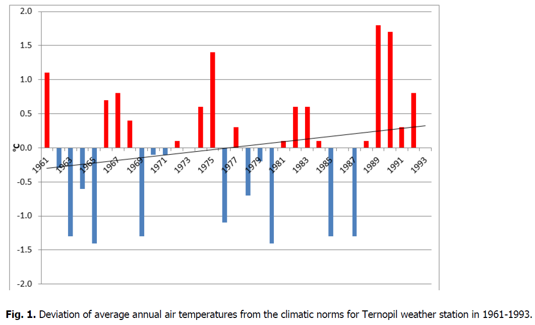
Figure 1: Deviation of average annual air temperatures from the climatic norms for Ternopil weather station in 1961-1993.
The maximum average annual temperature in 1989 was 8.5°C, while the minimum temperature was 5.3°C with the amplitude of the average annual changes for the specified period was 3.2°C. Analysis of average annual temperature deviations from the long-term climate norms shows their uneven distribution during the studied period (Table 1).
| Year | twed | A | tmax | date | tmin | date | Aextr- |
|---|---|---|---|---|---|---|---|
| Average | 6,7 | 24,6 | 52,8 | ||||
| Maximum | 8,5 | 34,2 | 34,5 | 11.08.1961 | -13,1 | 05.01.1990 | 64,0 |
| Minimum | 5,3 | 18,0 | 27,9 | 10.07.1980 | -31,6 | 09.01.1987 | 43,7 |
| Amplitude | 3,2 | 16,2 | 20,3 |
Table 1. Average values and amplitudes of an air temperature of Ternopil weather station in 1961-1993 period (in º?).
The period can be divided into two large phases, namely the phase before the 90s of the 20th century when the temperature fluctuates in a narrow range of 3-4 years. In the phase after the 1990s, the temperature exceeds the climate norms. As the trend line indicates, there is a gradual temperature rise throughout the period and an increase in average decade indicators from 6.5°C in the 60-the 70s to 7.0-7.1°C in the 80s-early 90s.
Analysis of annual amplitude changes of air temperature shows that their long-term norm is 24.6°С, and their amplitude within 1961-1993 years was 16.2°С. The most significant temperature variability within a year was observed in 1963 (34.2°С). High-temperature amplitudes were also indicated in 1964, 1985, and 1987, while the minimum annual temperature amplitudes were typical for 1990 (18.0°C) and 1989.
Also, important characteristics of the temperature regime are the maximum and minimum annual temperatures.
The amplitudes of changes in maximum average annual air temperatures range from 12.8 (1990) to 6.5°C (1969), while indicators for average annual minimum temperatures range from 4.7 (1989) to 0.2°C (1969).
Absolute maximum temperature in the period of 1961-1993 ranges from +34.5 (August 11, 1961) to +27.9°С (10.07.1980), with an amplitude of 6.6°С and a long-term norm of 30.5°С. During the same period, the absolute minimum air temperatures range from -13.1°C (December 5, 1990) to -31.6°C (January 9, 1987), with an amplitude of 18.5°C and a long-term norm of -22.4°C.
The absolute possible maximum of amplitudes of air temperatures for the studied period can be 66.1°С, while the maximum was reached in 1963 (+64.0°С) and the minimum was in 1990 (43.7°C) with an amplitude of changes of 20.3°C and a long-term norm of 52.8°C. Therefore, the actual temperature amplitude during the period was 2.1°C lower than the possible maximum.
Soil surface temperature largely determines its distribution in the air, especially in summer, while in winter, there is a reverse flow from warmer air, which was formed due to the invasion of the Atlantic air masses. The long-term norm of soil surface temperatures reaches + 8°С which is 1.3°С higher than in the air because of the warm seasons, and the amplitude of changes is 4.0°С which is 0.8°С higher than in the air (Table 2). The soil surface temperature also depends on the state of the undercover surface, granulometric composition and soil structure, its humidity, type of vegetation, relief, and in winter, it largely depends on the presence and condition of the snow cover. At meteorological stations, the soil surface temperature is measured by soil and alcohol thermometers which are applied by being set on the bare area in summer and on the snow cover in winter. The soil temperature at different depths is measured on the spots with natural grass cover.
| Year | Soil surface temperature | Air humidity | ||||||||
|---|---|---|---|---|---|---|---|---|---|---|
| twed. | A | tabs.min | Date | e | d | fwed | fmin | date | ||
| in °? | in hPa | in % | ||||||||
| Average | 8 | 28 | 8,7 | 3,1 | 80 | |||||
| Maximum | 10 | 38 | -15,0 | 15.02.1992 | 10,1 | 3,9 | 84 | 30 | 03.05.1991 | |
| Minimum | 6 | 23 | -39,0 | 06.01.1963 | 7,6 | 2,1 | 75 | 13 | 22.04.1962 | |
| Amplitude | 4 | 15 | 2,5 | 1,8 | 9 | |||||
Table 2. Average annual soil surface temperature and air humidity in Ternopil in 1961-1993.
During the studied period, the change in the soil surface temperature determined its distribution in the air. The distribution of the soil surface temperatures of 1961-1993 years coincides with the distribution in the air reaching the maximum of +10°С (1989) and the minimum +6.0°С (1987). The long-term norm of average soil surface temperatures is +8°С. The absolute minimum of soil surface temperature in 1961-1993 was observed on January 6, 1963, and was -39.0°С, 7.4°С lower than in the air, while the long-term norm was -25.1°С. The variability also characterizes the extreme minimum temperature within years of -24.0°C.
The ground frost is defined as lowering the air and soil temperature to 0°C and below based on the stable daily temperature. The part of the year when ground frost is not observed is called the frost-free period. Mostly ground frost is formed in the morning due to radiation cooling of the underlying surface layer and the air layer close to it. Ground frost is observed mainly in the transitional seasons of the year. Its formation is facilitated by evident, quiet weather and ordinary relief with an unprotected soil surface. Ground frost is more frequent and intense in open, bare areas and on asphalt, concrete, or stone surfaces of the city.
The average date of spring ground frost termination in Ternopil is the end of April, although it lasted until May for the majority of years. Depending on the characteristics of synoptic processes, the date of ground frosts' end may shift in one direction or another in different years. In abnormally warm springs (1982, 1987, 1990), frosts stop in the first decade of April, and in abnormally cold springs (1964, 1973, 1986), it is observed in early May (-4.0°C, 1.05.1965). The average deviation of the date of spring ground frost is 10-15 days. Autumn ground frost on the soil surface can begin in some years (1961, 1963, 1989, 1992) at the end of September. In September, soil surface temperatures are lower than 0°C, reaching -6.0°C (30.09. 1993). Frost is especially dangerous for growing crops, especially vegetable and fruit crops.
The first autumn ground frost in Ternopil usually begins with early invasions of cold air masses from the Arctic, and in warm autumns, it may start at the beginning of October (1998). The average deviation of autumn frost start is 15 days. The average duration of the frost period in Ternopil is 140 days. Fluctuations in the dates of frost occurrence and termination cause significant variability in the duration of the frost-free period in some years. Due to its "thermal effect", the duration of the frost-free period is slightly longer, spring ground frost stops earlier, and in autumn, it occurs later than outside the city.
One of the essential characteristics of the humidification of the territory is the air humidity determined by the circulation processes, air temperature, the underlying surface, the amount of precipitation.
The primary method to measure humidity is psychrometric, based on the temperature difference between dry and wet bulb thermometers installed at the height of 2 m in an instrument shelter. Three indicators estimate the air vapor content in the air: partial water vapor pressure, relative humidity, and humidity deficit. Each of them is closely related to the distribution of temperature and precipitation. While there is a direct correspondence between indicators of water vapor elasticity and saturation deficit in their distribution, there is a reversal correspondence for relative humidity.
The further step is to do the calculations basing on this difference according to the psychrometric formula or psychrometric tables. The average long-term norms of water vapor elasticity in 1961-1991 were 8.7 hPa with an amplitude of 2.5 hPa and saturation deficits of 3.1 and 1.8 hPa (Table 2), respectively.
The highest magnitudes of water vapor elasticity (e) were in 1989 (10.1 hPa), and the saturation deficit (d) of the highest values was in 1961 (3.9 hPa).
The minimum amount of water vapor elasticity was observed in 1986 (7. 6 hPa), and saturation deficit (d) was in 1980 (2.1 hPa). The amplitude of changes in the average annual values of elasticity and saturation deficit of water vapor during these periods was 2.5 hPa and 1.8 hPa, while the water vapor elasticity tends to fall, and the saturation deficit tends to increase (Fig. 2).
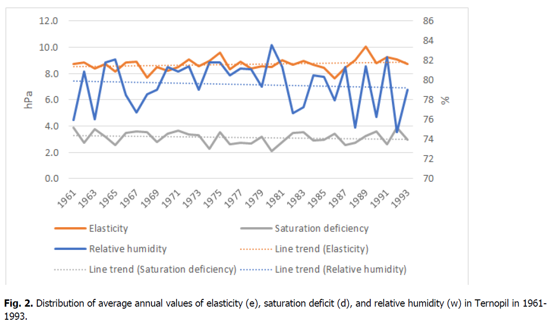
Figure 2: Distribution of average annual values of elasticity (e), saturation deficit (d), and relative humidity (w) in Ternopil in 1961-1993.
The average long-term norm of relative humidity for the studied period was 80%, a quality characteristic of a humid type climate and determines a certain comfort level of climatic conditions for a human living (Table 1). The highest values of relative humidity were observed in 1980 (84.0%). After that period, a decrease in relative humidity and a minimum of its values fall in 1992 (75.0%), which reversely correlates with the temperature data, which is proved by the trend line demonstrating a tendency to fall. Precipitation occurs mainly at the relative humidity from 80% to 100%. However, it stops at a relative humidity of 40% and less. The minimum values of relative humidity per day fell to 13% (April 22, 1962), with an average norm of 23% (Table 2).
The average annual rate of atmospheric pressure is 976.7 hPa, and the amplitude of changes within years is recorded to be insignificant–o nly 4.5 hPa (Table 3). The maximum atmospheric pressure values were observed in 1961 (978.9 hPa), and high atmospheric pressure was recorded in 1972, 1983, and 1991, characterized by anticyclone weather types accompanied by increased temperature in summer and low air temperature in winter with a lower amount of precipitation.
| Years | Atmospheric pressure | Cloudiness | Precipitation | ||||
|---|---|---|---|---|---|---|---|
| Pwed | A | Covering in points | Rsum | Rmax_day | Date | ||
| in hPa | General | Lower | in mm | ||||
| Average | 976,7 | 11,0 | 6,4 | 3,6 | 602,6 | ||
| Maximum | 978,9 | 20,6 | 7,9 | 4,5 | 839,4 | 78,6 | 22.06.1969 |
| Minimum | 974,4 | 5,4 | 5,8 | 3,1 | 369,8 | 21,9 | 13.05.1970 |
| Amplitude | 4,5 | 15,2 | 2,1 | 1,4 | 469.6 | ||
Table 3. Average annual values of atmospheric pressure, cloudiness and precipitation in Ternopil in 1961-1993.
The lowest atmospheric pressure was recorded in 1970 (974.4 hPa). Low atmospheric pressure was also observed in 1966, 1974, 1981, 1988. The frequency of changes in atmospheric pressure is uneven. Periods of low atmospheric pressure lasted for 5-7 years, while similar periods of high pressure lasted only 1-2 years.
The changes in the radiation regime determine the wind regime in the Ternopil plateau, and consequently, the thermal regime during the year, as well as by the pressure dynamics over the territory. The wind speed depends on the horizontal baric gradient; its direction depends on where high and low-pressure areas are located. Wind direction and speed were measured at meteorological sites at the altitude of 10-12 m through Wild's wind vane or anemorumbometers for microclimatic observations.
The long-term wind speed norm is 3.4 m/s with an amplitude of 1.6 m/s. The decrease in wind speed has been revealed due to the minimum wind speeds of 2.1 m/s (1993). However, average decade values range from 2.9m/s in the 60s to 2.8 m/s in the 70s and 2.6m/s in the 80s (Fig. 3).
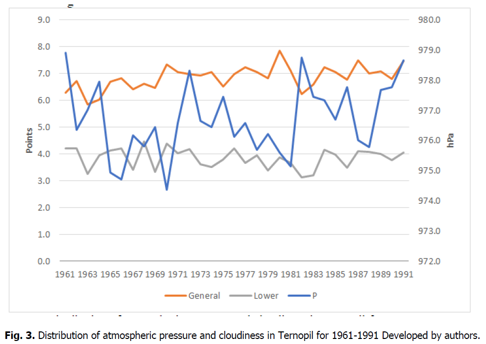
Figure 3: Distribution of atmospheric pressure and cloudiness in Ternopil for 1961-1991 Developed by authors.
The stability of the wind regime with high wind speed has become a characteristic of the recent period. The 60s of the 20th century was an unstable period in terms of wind speed. After that, there is an increase in wind speed, reaching 4.2 m/s in 1992. Maximum wind speed in 1961-1993 also has a multi-vector change tendency reaching maximum values of 28 m/s in 1979, while minimum values of 15 m/s were in January 1966. The general tendency proves a gradual decrease in wind speed from 28 m/s in June 1979 to 15 m/s in January 1966. The average maximum wind speed for 1961-1993 was 22.2 m/s (Fig. 4).
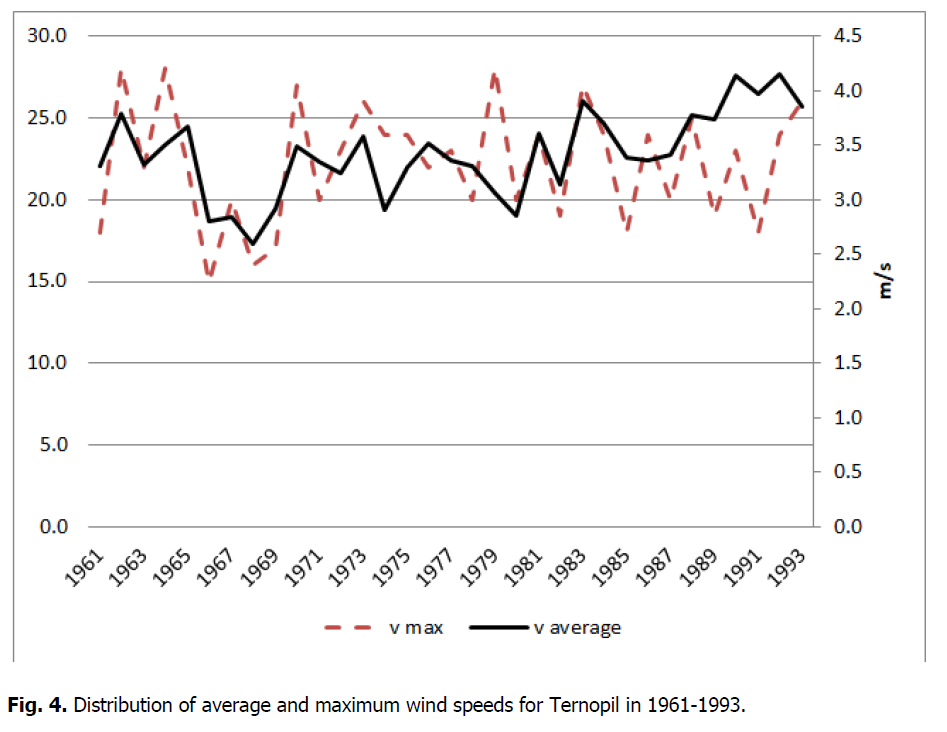
Figure 4: Distribution of average and maximum wind speeds for Ternopil in 1961-1993.
The presentation of wind direction in the diagram demonstrates that the long-term prevailing winds are northwest (246) and western (236) rhumb, and the least present wind is northeast rhumb (60) (Fig. 5).
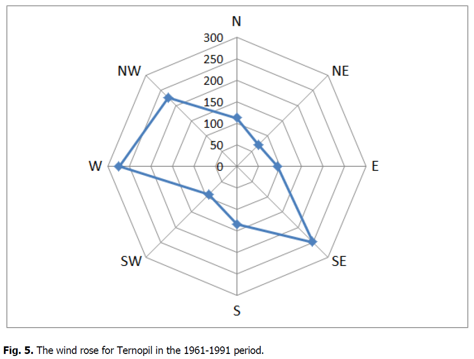
Figure 5: The wind rose for Ternopil in the 1961-1991 period.
This indicates the predominance of the Atlantic air during the year and its significant impact on forming the temperature and precipitation regime.
Cloudiness during 1961-1993 is characterized by a long-term norm of 6.4 points of total cloudiness with the amplitude of changes of 2.1 points, while similar values for the clouds of the lower tier are respectively 3.5 and 1.4 points (Table 3). The measurement is carried out by visual observations and using altimeters that measure the lower height of the clouds.
Cloud change dynamics demonstrate their reasonably even distribution over the years with total clouds and lower-tier clouds. Thus, the maximum cloudiness value was reached in 1980, with total cloudiness of 7.9 points and lower-tier clouds of 4.5 points.
The minimum values of 5.8 points (in 1963) and 3.1 points for the lower cloudiness were observed in 1982. The tendency of average cloudiness values for decades is the following (in points): in the 60s - 6.5 – total, 4.0 – lower cloudiness; in the 70s 7.0-total, 3.8–lower cloudiness; in the 80s 6.9–total, 3.8 lower cloudiness (Fig. 3).
Therefore, there is a tendency for the gradual growth of cloudiness to the 80s of the 20th century. It causes that the total solar radiation supply of the Earth's surface is increasing. Increased cloudiness reduces temperature amplitudes during the day and seasons, increases the humidity values, leads to more frequent precipitation. However, the direct solar radiation supply decrease negatively affects plant growth and recreational activities, especially in the summer.
Precipitation is one of the essential characteristics of the climate. It affects the nature of the moisture circulation on a certain territory, erosion processes, vegetation, and various types of human economic activities (agriculture, transport). Precipitation occurs from altostratus clouds (As), nimbostratus clouds (Ns), stratus clouds (St), and cumulonimbus clouds (CuNb) in the form of liquid (rain, torrential rain, shower, mist), in a solid-state (snow, hail, snow grains), or a mixed state (sleet, wet snow and torrential wet snow).
The amount of precipitation is measured by the height of the water layer (mm) fallen over a certain period: hour, day, month, year. It is measured at meteorological sites with the help of Tretiakov's rain gauge and a pluviograph that records both the amount of precipitation and its intensity.
The city of Ternopil is located in a zone of sufficient moisture. The precipitation during the year is mainly caused by a cyclonic activity and is intensified when cold and warm atmospheric fronts pass. Cyclones, moving from the Atlantic Ocean and the Mediterranean Sea, bring up to 80% of the annual amount of moisture. The average amount of precipitation per year is 602.6 mm (Table 3). In summer there is a significant amount of precipitation (234.7 mm, 38.6%), in spring it is 143.1 mm (24.3%), in autumn it is 124.1 mm (20.3%), and in winter there is the least amount of precipitation (101.4 mm, 16.8%). Consequently, 438.5 mm (72.7%) of precipitation falls in the form of rain in the warm period of the year from April to October (Fig. 6).
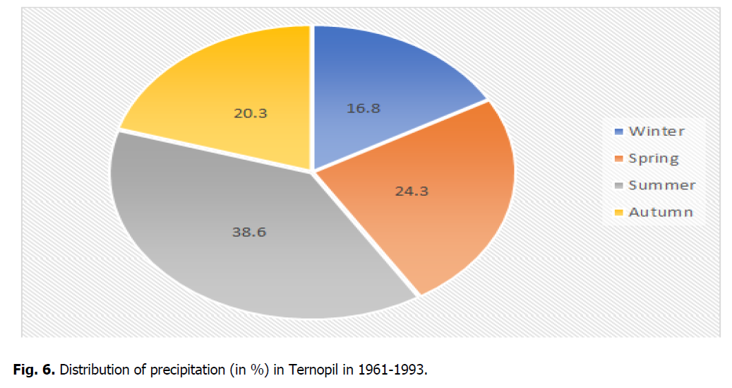
Figure 6: Distribution of precipitation (in %) in Ternopil in 1961-1993.
Precipitation in the form of rain can also occur in the cold season from November to March. During the year, the most significant amount of precipitation is observed in July-92.2 mm (15.3% of the annual rate), and the smallest amount is in February - 31.9 mm (5.3%) of the annual norm (Fig. 6).
The city of Ternopil is characterized by a moderate-continental type of precipitation with a maximum in summer months and a minimum in January and February. Maximum precipitation occurs due to cyclone weather types and the development of local convective cloudiness. Cyclones are especially active in the winter months, as well as in transitional seasons. They mainly come from the west and northwest of the Atlantic. However, causing snowfalls. The distribution of precipitation throughout the year reflects a complex system of atmospheric circulation and temperature, especially in the warm season, when the role of thermal conditions in the precipitation formation increases. The most significant number of days with solid precipitation is recorded in January. From winter to spring, the amount of solid and mixed precipitation decreases, and by the end of March, they stop occurring. Solid precipitation in summer can fall only in the form of hail from cumulonimbus clouds.The frequency of precipitation is defined by the number of days with its different amount. A precipitation day is considered to be a day with precipitation of 0.1 mm or more. On average, Ternopil has 175 precipitation days and 42 days with precipitation signs. The most extensive precipitation days (17-19) are recorded in December and January, and the smallest number (11-12) is in September -October.
During the studied period (1961-1993), the average annual precipitation norm was 588.7 mm in the '60s, 646.8 mm in the '70s, and 581.4 mm in the '80s; the lowest value was in the early 90's - 572.3 mm. The line trend does not indicate a change in precipitation tendency and demonstrates a precipitation increase during 1961-1993 (Fig. 7). The fluctuation amplitude within years was 469.6 mm.
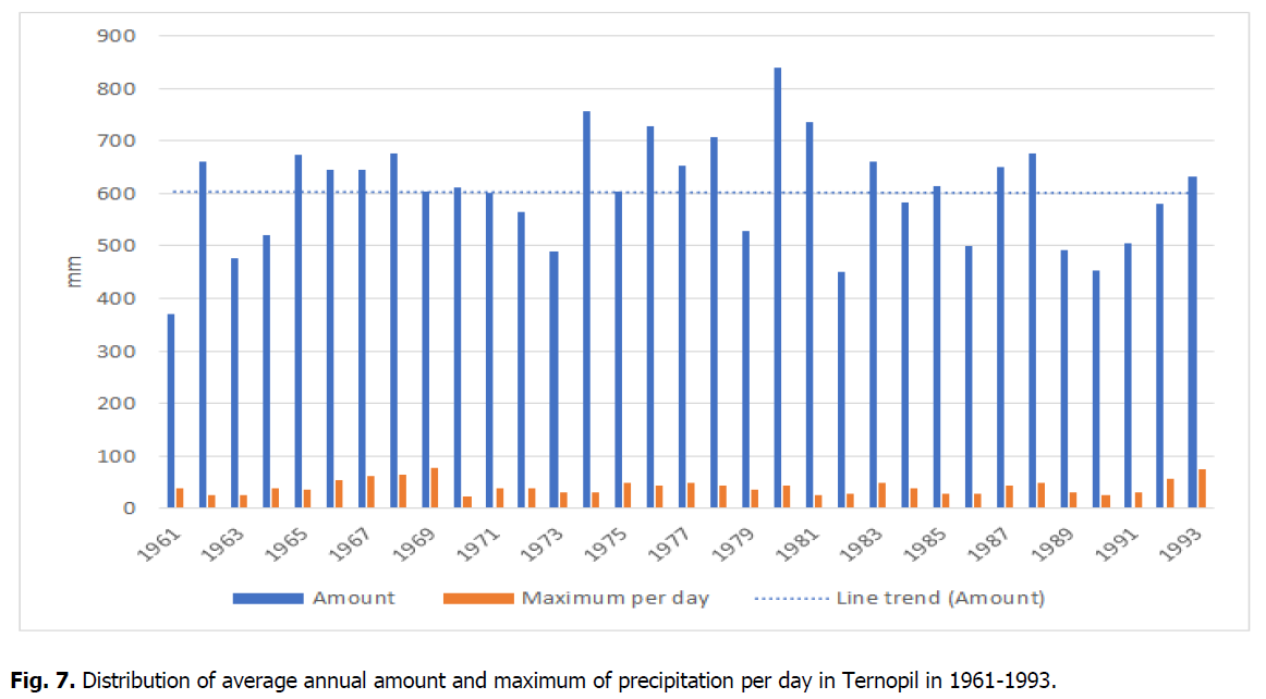
Figure 7: Distribution of average annual amount and maximum of precipitation per day in Ternopil in 1961-1993.
During this period, years with an annual amount of precipitation exceeding the norm by 120% were 1974, 1976, 1980; the year of maximum precipitation was 1980 with 839.9 mm, or 139.4% of the norm (Fig. 7).
The minimum precipitation occurs in 1961 with 369.8 mm or 61.4%, and the amount of precipitation below 80% is observed in 1961, 1963, 1982, 1990. The frequency of a relatively humid period occurrence in the 70s was 2 cases with a maximum duration of up to 4 years; the relatively dry years in the 70s also had 2 cases with the duration from 1 to 2 years in the beginning and three years with the increased rate of precipitation. In the 80s, increased precipitation and relative dryness were 1-2 years; therefore, a high change frequency is observed.
The first half of the 90s of the 20th century had the most extended period with precipitation lower than the climatic norm (Fig. 8). The long-term norm of precipitation per day was 41.1 mm with maximum precipitation of 78.6 mm, recorded on June 22, 1969. Snow cover has a significant impact on the formation of the landscape climate in winter. It protects the soil from deep freezing, creates more favorable conditions for surviving park and garden vegetation.
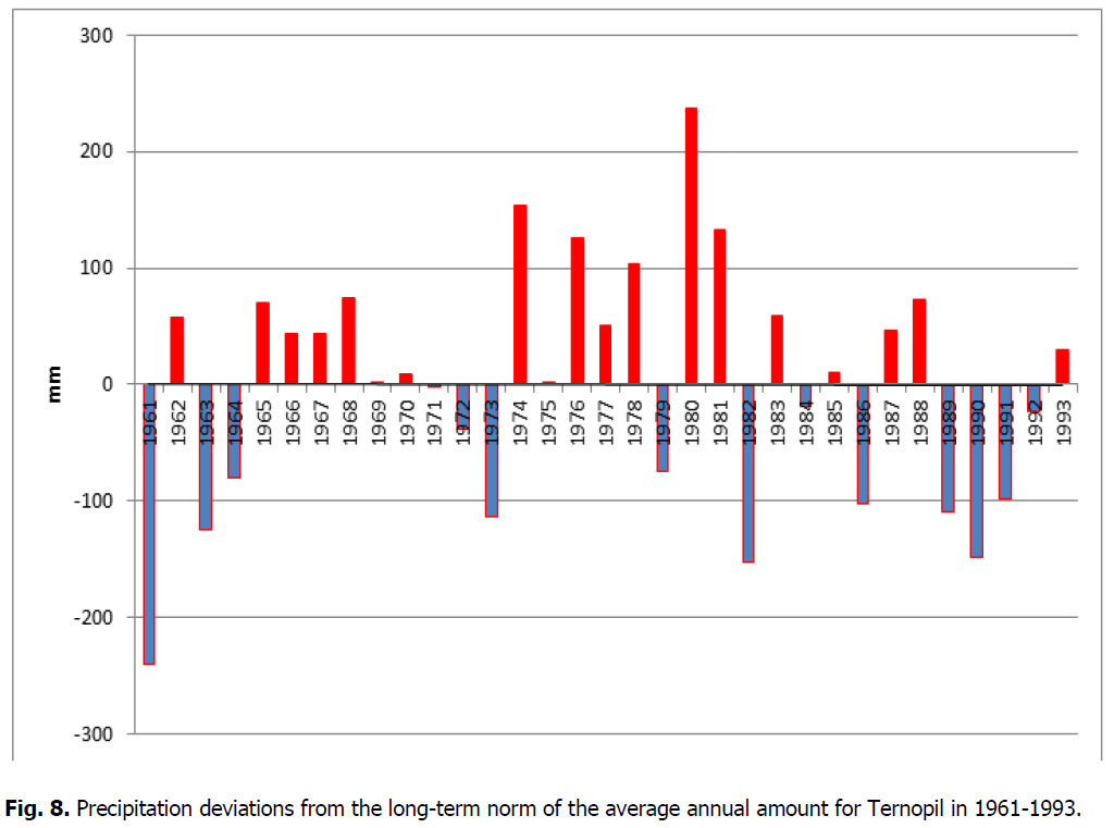
Figure 8: Precipitation deviations from the long-term norm of the average annual amount for Ternopil in 1961-1993.
Snow cover forms different and uneven distribution in the landscape caused by buildings, parks, forests, agricultural land which differently affect wind direction and speed. At the same time, the snow cover negatively affects road and rail transportation. Heavy snowfall prevents the safety of the traffic.
Snow cover significantly affects the air temperature regime. Snow cover is characterized by a high solar radiation reflective property (albedo). An albedo of snow, which has just fallen, is 85-90%. However, the albedo of wet snow will be much lower, especially in the city, due to pollution of the snow cover.
In winter, the snow surface absorbs about 40-50% of the heat coming in total radiation. The first snow cover occurs in the city later than in the countryside.
When spring is early and warm, snow can melt at the end of February (1964, 1969, 1980, 1987.). For Ternopil, this tendency is expressed in 1-2 days due to the middle size of the city. The final snow cover melts in Ternopil at the end of March. The dates of snow melting vary within 10 days.
In Ternopil, snow cover lasts approximately 90-110 days. In winter 1966, snow remained 37 days, and in winter 1973, it was for 130 days. The height of the snow cover gradually increases from the moment of its first falling: in November, it is 1 cm, in January - February, it is 10-11 cm. From the third decade of March, the height of the snow cover begins to decrease to 2 cm.
Snow cover is storage of moisture. The water accumulation is defined by the thickness of the water layer (mm) formed on a horizontal surface due to snow melting when such factors as run-off, impregnation, and evaporation are absent. Heavy snowfall when more than 20 mm of precipitation falls within less than 12 hours causes significant difficulties in the city. In Ternopil, heavy snowfall is rarely recorded, especially in recent winters. The period of constant snow cover (from December to February) in Ternopil and its suburbs can be used for winter recreation and holiday activities.
Conclusion
Based on climatic materials published in «Meteorological monthly journals» and material collections, climatic specificity of the Ternopil weather station as a representative object for the Ternopil plateau landscape (the period of 1961-1993) has been analyzed. Our results could be used to form a strategy for developing the Pidhorodnianska village united territorial community, Pidhorodnianska OTG, for the period up to 2027 (part of this territory is located within the Ternopil plateau).
In particular, to substantiate the impact of climatic conditions on the development of recreational tourism, ecotourism, as well as to determine the prospects for growing individual crops, vegetables, and horticulture.
The thermal regime for the studied period is characterized by an average annual temperature of +6.7°C (+8.0°C on the soil surface) with the highest deviation of +1.8°C in 1989 (+8.5°C) and in 1980 ( -5.3°C). The maximum temperature amplitude for the studied period was 3.2°C. The absolute possible maximum air temperature amplitude for the period can be 66,1°C, while within the year maximum was reached in 1963 (+64.0°C), and the minimum was in 1990 (43.7°C) with the change amplitude of 20.3° and long-term norm of 52.8°C. The first autumn ground frost in Ternopil begins with an early invasion of cold air masses from the Arctic, which happens in the third decade of October in warm autumns and lasts until the first decade of April.
Humidity is characterized by the average long-term norm of 8.7 hPa of water vapor elasticity, 3.1 hPa of humidity deficit, and 80% relative humidity, respectively, to temperature distribution, proving high and indicating the influence of humidity marine air masses and relatively high relief.
Atmospheric pressure is a consequence and reason for the weather conditions formation, namely, wind, cloudiness, and precipitation. The average annual atmospheric pressure norm is 976.7 hPa.
The wind regime of the territory is characterized by a long-term average norm of 3.4 m/s, and the predominant winds are NW, W, and SE of rhumbs differentiated by seasons.
Cloudiness during 1961-1993 is characterized by a long-term norm of 6.4 points of total cloudiness with a changing amplitude of 2.1 points respectively, while similar values for clouds of the lower tier are 3.6 and 1.4 points, respectively. The precipitation rate in 1961-1993 was 602.6 mm with an amplitude of fluctuations within the years of 469.6 mm from 839 mm (1980) to 369.8 mm (1970) recorded on June 22, 1969.
In the landscape of the Ternopil plateau, the distribution of precipitation within seasons is uneven. A significant amount of precipitation of 234.7 mm (38.6% ) is observed in summer; in spring, it is 143.1 mm (24.3%), in autumn, it is 124.1 mm (20.3%), and the least amount is recorded in winter -101.4 mm (16.8%); consequently, precipitation in the form of rain is 438.5 mm (72.7%) in the warm half of the year from April to October.
According to climatic characteristics, the climate of the landscape of the Ternopil plateau belongs to the humid temperate warm zone. It is favorable for agricultural activities (grain farming, sugar beet, and vegetable cultivation), forestry, and livestock. It is also favorable for recreational activities, especially in late spring, summer, and autumn (hiking and agro-tourism). At the same time, these conditions can lead to erosion development, floods due to abnormal meteorological indicators in some years.
Over the studied period, the dynamics of climate change affect the change of other landscape components (soils, flora, and fauna), people's economic activity, characteristics, and the intensity of dangerous natural phenomena.
References
Houghton, J.T., Ding, Y.D.J.G., Griggs, D.J., Noguer, M., van der Linden, P.J., Dai, X., Johnson, C.A. (2001). Climate change 2001: the scientific basis. The Press Syndicate of the University of Cambridge.
Meteorology monthly journal. (1961).
Babichenko, V.M. (2008). Changes in air temperature in Ukraine at the end of the twentieth century and early XXI century. Heohrafiia v Informatsiinomu Suspilstvi.
Osadchyi, V.I., Babichenko, V.M. (2010). Temperature regime on the territory of Ukraine. Ukrainskyi Naukovo-doslidnyi Hidrometeorolohichnyi Instytut.
Konstantynov, A.R., Sakali, L.Y., Hoisa N.Y., Oliinyk, R.N. (1966). Thermal and water regime of Ukraine. K: Hidrometeovydav, p:592.
Boychenko, S.G., Voloshchuk, V.M., Serdiuchenko, N.N. (2017). Modern space-time variations of the index of continentality and the amplitude of a seasonal course of the surfase air temperature on the territory of Ukraine. Dopov Nac Akad Nauk Ukr, 9:67-75.
Osadchyi, V., Skrynyk, O., Radchenko, R., Skrynyk, O. (2018). Homogenization of Ukrainian air temperature data. International Journal of Climatology, 38:497-505.
Author Info
N.B. Taranova*, T.B. Zastavetskyi, M.R. Pytuliak and M.V. PytuliakCitation: Taranova, N.B., Zastavetska, L.B., Zastavetskyi, T.B., Pytuliak, M.R., Pytuliak, M.V. (2021). Analysis of climate changes on the Ternopil plateau in 1961-1993 basing on the average annual data. Ukrainian Journal of Ecology, 11 (6), 7-17.
Received: 04-Jul-2021 Accepted: 20-Jul-2021 Published: 23-Aug-2021
Copyright: This is an open access article distributed under the terms of the Creative Commons Attribution License, which permits unrestricted use, distribution, and reproduction in any medium, provided the original work is properly cited.
